 Acadia Learning brings scientists, teachers, and students together in partnerships that result in useful research and effective science education.
Brief description
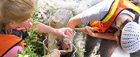
The schoolyard and the area surrounding the school are the study site for this project. Students will gather data about the study area to use to develop their research question, claim and research design.
Background for Teachers
For many students the schoolyard and area surrounding the school are just that, a schoolyard. The students will need to recast in their mind the schoolyard and environs as a field site. For this lesson your students will use maps and a field reconnaissance to develop an understanding of the schoolyard and surroundings as that field site, and how features of that field site may affect characteristics of snowfall, snowpack and snowmelt.
For this project you will be collecting precipitation data using the CoCoRaHS materials and protocols. You will upload the data you collect using these materials to the CoCoRaHS website. The CoCoRaHS sampler stays in a fixed location, out in a clearing for the duration of the project. This will give your students time-series data on winter-time precipitation in a clearing. What does it tell us about changes in snowpack over the course of the winter or how microclimates affect snowfall, snowpack and snowmelt?
To answer those types of questions you have a snow-corer, a thermometer, CoCoRaHS snow depth ruler, CoCoRaHS snow gauge and a 10” (25.4 cm)-diameter plastic disc, or snow board, that is used as a flat surface for measuring new snow amounts. Your students can use these materials (as well as digging snowpits) to acquire data from any number of locations around the schoolyard to help answer questions about changes in snowpack over the course of the winter or how microclimates – like different forested areas - affect snowfall, snowpack and snowmelt or how snow profiles (the different layers of the snowpack) change through the winter. But, first they need to see the field site potential of the area around the school.
Goals
- Students see the area around the school as a diverse collection of microclimates that may affect snowfall, snowpack, and snowmelt throughout the winter.
Outcomes
- Students create a detailed map of the area around the school.
- Students ask tentative questions about how the characteristics of the potential sites may affect snowfall, snowpack and snowmelt throughout the winter.
- Students identify a location to place the CoCoRaHS precipitation sampler.
Where does this lesson happen in the Project?
This is the fourth lesson in the project.
Getting Ready
- Ask your students to describe the area around the school. Ask a student to draw a map (preferably on the board) while the students are describing.
- Ask your students to come up with plausible ways in which some of the different features drawn on the map may affect snowfall, snowpack and snowmelt throughout the winter. Record the answers.
- Explain that the students will be making a map of the area around the school to assess its potential as a field site to study snow, and that they also need to find a location to place their precipitation sampler for the winter.
Materials
- CoCoRaHS protocol on siting the precipitation collector.
- Field guides (trees, plants)
- Access to Google maps or Google Earth (or if your school has a site map then use that as the base for the mapping done by the students)
- Prevailing wind data (file: Prevailing winds in Maine 1930-1996)
- Map of Maine’s Climate Divisions (file: MaineClimateDivisions.gif, from )
- Topo maps (if you do not have any you can download ones, or buy ones from the USGS Map Locator and Downloader: )
- Tape measures
- Compass
- Camera
- Plain paper
- Pencils
- Clipboards
- If you want to create a master map then you will need a large sheet of paper or topographic map
- Table of Field Variables
- Map template
- Questions worksheet
Student Prerequisites
- Students should be able to recognize that a map is a graphical picture of an area and that maps show how places are related to each other by distance, direction, and size.
- Students should know how to use a field guide.
Time needed
One class period
Doing the Activity
Explain to your students that the school area will be the field site for this project and that the field site needs to be mapped. The mapping will help to determine where sampling can occur. The mapping will also determine where the CoCoRaHS precipitation sampler will be placed.
Have students read the CoCoRaHS protocol for placing the sampler.
Review the Table of Field Variables with your students and discuss how these different variables may affect snow (the information is on the Table). Create a list of factors that you will need to put on your map, such as:
- Elevation
- Latitude and Longitude
- Direction
- Landcover type(s) including fields, wetlands, bogs, forest types, developed areas, playing fields
- Size of each feature (estimated or measured where possible)
- Prevailing wind
- Man-made features
- Waterbodies
Using a site map, Google Maps, Google Earth and/or a topographic map identify the area around your school to map. Verbally describe the area from the map(s) at hand. Identify possible locations for the CoCoRaHS sampler.
Gathering your field supplies, head into the field to collect the information you will need from a field reconnaissance field trip. Have students identify and map features around the schoolyard. Continuously ask: How do you think this feature will affect snowfall, snowpack or snowmelt? Try to bring in common experiences to help students consider these influences (for example, when it’s snowing, would you get more or less snow falling on your head under a softwood tree than in the open? Is it windier or less windy in the forest or in the open?)
Once back in the classroom assemble all information into one map (use the site map from your school, a print out of a Google map or the topographic map as the base layer… or put all of the information into Google Earth).
Add to the map the information that comes from other sources (prevailing wind, latitude and longitude, in which of Maine’s Climate Divisions the school is located). Identify possible locations for the CoCoRaHS sampler.
Note: If breaking your students into groups to do the mapping then establish a consistent code (PA=pavement, DEC=deciduous, CON=coniferous, FOR=forest, PLAYFIELD=playing field, whereas FLD=field, etc.)
Also, if breaking your class into groups (or spreading the work over multiple sections of the same class) it may be best to place a grid over the area and assign students to record information about different parts of the site.

Figure 1: Example of splitting up the field site from:
Additionally
Use the question worksheet to have your students record any questions that have emerged from doing the field reconnaissance.
Assessment
Formative
Ensure that students are familiar with birds-eye-view perspective while creating the map.
Summary
Evaluate the map for thoroughness of detail and accuracy.
Lesson Extensions and Supplements
- Students may want to photograph the different types of trees and sites around the school.
- Ask the school maintenance department where they leave the plowed snow in the winter (a place to avoid sampling).
- Ask if sand and salt is used around the school and where the sand and salt is stored.
- Students may want to research snow shedding characteristics of different trees.