 Acadia Learning brings scientists, teachers, and students together in partnerships that result in useful research and effective science education.
Planning and carrying out investigations
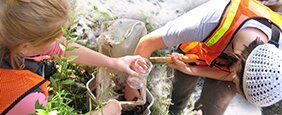
Protocol 3: Determining Stream Slope with Topo Map or Clinometer
A field protocol for using topo maps or clinometer to collect data on stream or watershed slope
Types of Instruction:
- Fieldwork
Subjects:
- Earth Science, Life Science
Topics:
- Earth's Surface Systems, Human Impacts, Interdependent Relationships in Ecosystems, Planning and carrying out investigations
Skills:
- collecting data, following protocols, map reading, measuring, sampling
Standards:
Obtaining, evaluating, and communicating information